| dc.coverage.spatial | Site: Agrigento, Sicily, Italy | en_US |
| dc.coverage.temporal | ca. 580-200 BCE (inclusive) | en_US |
| dc.creator | unknown (Greek (ancient)) | en_US |
| dc.date | -580--200 | en_US |
| dc.date.accessioned | 2013-03-20T18:03:21Z | |
| dc.date.available | 2013-03-20T18:03:21Z | |
| dc.date.issued | -580--200 | en_US |
| dc.identifier | 202108 | en_US |
| dc.identifier.other | archrefid: 1076 | en_US |
| dc.identifier.uri | http://hdl.handle.net/1721.3/109904 | |
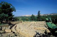
| dc.description | View over a road cut into rock; Greek colony on the southern coast of Sicily. Believed to have been founded ca. 580 BCE from Gela, a city further down the coast, it flourished as an independent state until 406 BCE, when it was sacked by the Carthaginians. It maintained some degree of independence until the Roman conquest of Sicily in 210 BCE. The extensive town, lying some 2 km from the sea, was enclosed by walls following natural precipices and includes a steep acropolis now occupied by the modern settlement. Source: Grove Art Online; http://www.groveart.com/ (accessed 1/28/2008) | en_US |
| dc.rights | © Scott Gilchrist, Archivision, Inc. | en_US |
| dc.subject | architectural exteriors | en_US |
| dc.subject | death or burial | en_US |
| dc.subject | Greek (ancient) | en_US |
| dc.title | Agrigento: Roads and Necropolis | en_US |
| dc.title.alternative | Akragus: Roads and Necropolis | en_US |
| dc.type | image | en_US |
| dc.rights.access | Licensed for educational and research use by the MIT community only | en_US |
| dc.identifier.vendorcode | 1A3-G-AG-6-A1 | en_US |
| vra.culturalContext | Greek (ancient) | en_US |
| vra.technique | construction (assembling) | en_US |
| vra.worktype | street | en_US |
| vra.worktype | necropolis (cemetery form) | en_US |
| vra.worktype | excavation (site) | en_US |
| dc.contributor.display | unknown (Greek (ancient)) | en_US |


