| dc.coverage.spatial | Site: Las Vegas, Nevada, United States | en_US |
| dc.coverage.temporal | 1992 (creation) | en_US |
| dc.creator | Gilchrist, Scott | en_US |
| dc.date | 1992 | en_US |
| dc.date.accessioned | 2013-03-20T14:22:23Z | |
| dc.date.available | 2013-03-20T14:22:23Z | |
| dc.date.issued | 1992 | en_US |
| dc.identifier | 201505 | en_US |
| dc.identifier.other | archrefid: 1132 | en_US |
| dc.identifier.uri | http://hdl.handle.net/1721.3/109267 | |
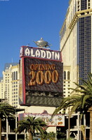
| dc.description | Casino neon light sign for Aladdin; The Las Vegas Strip (also known as The Strip and to local residents as The Boulevard) is 4 mi (6.7 km) of Las Vegas Boulevard South partly in Las Vegas, Nevada, United States, that has been designated an All-American Road. Many of the largest hotels, casinos and resort properties in the world are located on The Strip. Over the years, Las Vegas Boulevard South has been called Arrowhead Highway, Salt Lake Highway, U.S. Highway 91, and "Los Angeles Highway". The Strip was reportedly named by police officer Guy McAfee, after his hometown's Sunset Strip, in Los Angeles. Source: Wikipedia; http://en.wikipedia.org/wiki/Main_Page (accessed 2/1/2008) | en_US |
| dc.rights | © Scott Gilchrist, Archivision, Inc. | en_US |
| dc.subject | architectural exteriors | en_US |
| dc.subject | business, commerce and trade | en_US |
| dc.subject | cityscapes | en_US |
| dc.subject | contemporary (1960 to present) | en_US |
| dc.subject | marquees | en_US |
| dc.subject | Neon signs | en_US |
| dc.subject | Street lighting | en_US |
| dc.subject | Twentieth century | en_US |
| dc.title | Las Vegas Strip: Topographic Views | en_US |
| dc.type | image | en_US |
| dc.rights.access | Licensed for educational and research use by the MIT community only | en_US |
| dc.identifier.vendorcode | 1A2-US-LV-LS-E1 | en_US |
| vra.culturalContext | American | en_US |
| vra.technique | photography | en_US |
| vra.worktype | photograph | en_US |
| vra.worktype | topographical view | en_US |
| dc.contributor.display | Scott Gilchrist (Canadian photographer, born 1960) | en_US |


