MIT Libraries logoDome

MIT
View Item 
  • Dome Home
  • Visual Collections
  • Architecture, Urban Planning, and Visual Arts
  • View Item
  • Dome Home
  • Visual Collections
  • Architecture, Urban Planning, and Visual Arts
  • View Item
JavaScript is disabled for your browser. Some features of this site may not work without it.

Mystras: Topographic Views

Gilchrist, Scott
Thumbnail
Download1A3-B-G-M-1-A6_cp.jpg (705.9Kb)
Alternate file
1A3-B-G-M-1-A6_sv.jpg (2.535Mb)
1A3-B-G-M-1-A6_tm.jpg (21.78Kb)
URI
http://hdl.handle.net/1721.3/103113
Date
1997
Description
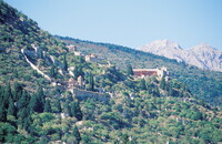
View of the site, from the southeast, the upper town; Mystras (also Mistra, Mystra and Mistras) was a fortified town in Morea (the Peloponnesus), on Mt. Taygetos, near ancient Sparta. It lies approximately eight kilometres west of the modern town of Sparti. Mystras was also the last centre of Byzantine scholarship. In 1989 the ruins, including the fortress, palace, churches, and monasteries, were named a UNESCO World Heritage Site. Source: Wikipedia; http://en.wikipedia.org/wiki/Main_Page (accessed 7/17/2008)
Type of Work
topographical view; photograph
Subject
agriculture, architectural exteriors, cityscapes, landscapes, Twentieth century
Rights
© Scott Gilchrist, Archivision, Inc.
Rights Statement
Licensed for educational and research use by the MIT community only
Metadata
Show full item record

Collections
  • Architecture, Urban Planning, and Visual Arts

Browse

All of DomeCommunities & CollectionsBy Issue DateCreatorsTitlesSubjectsThis CollectionBy Issue DateCreatorsTitlesSubjects

My Account

Login
MIT Libraries
PrivacyPermissionsAccessibilityContact us
MIT
Content created by the MIT Libraries, CC BY-NC unless otherwise noted. Notify us about copyright concerns.