Grand Canal; Topographic Views
Download1A2-I-VE-GC-D8_cp.jpg (568.9Kb)
Date
1996Description
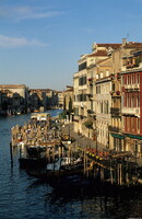
View looking west down the canal, from the top of the Rialto Bridge, depicting the quay; The Grand Canal (Italian: Canal Grande, Venetian: Canałasso) is the most important canal in Venice, Italy. It forms one of the major water-traffic corridors in the city. Public transport is provided by water buses and private water taxis, but many tourists visit it by gondola. At one end the canal leads into the lagoon near Santa Lucia railway station and the other end leads into Saint Mark Basin: in between it makes a large S-shape through the central districts ("sestieri") of Venice. It is 3800 m long, 30-90 m wide, with an average depth of five meters. Source: Wikipedia; http://en.wikipedia.org/wiki/Main_Page (accessed 7/4/2008)
Type of Work
topographical view; photographSubject
architectural exteriors, business, commerce and trade, cityscapes, seascapes, Boats and boating, City planning, Housing, Transportation, Twentieth century
Rights
Rights Statement
Licensed for educational and research use by the MIT community only