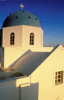
Island of Thira: Topographic Views
Gilchrist, Scott

Download1A2-G-S-SO-C10_cp.jpg (346.8Kb)
Date
1997Description
View of a typical church dome (Byzantine in style) found north of Thira; Santorini is a small, circular group of volcanic islands located in the Aegean Sea, about 200 km south-east from the mainland of Greece. It is also known by the name of the largest island in the archipelago, Thera (or Thira). It is the southernmost member of the Cyclades group of islands, with an area of approximately 73 sq km (28 sq mi), and in 2001 had an estimated population of 13,600. A giant central lagoon, more or less rectangular and measuring about 12 km by 7 km (8 mi by 4 mi), is surrounded by 300 m (984 ft) high sheer cliffs on three sides. The island slopes downward from the cliffs to the surrounding Mediterranean sea. On the fourth side, the lagoon is separated from the Mediterranean by another much smaller island called Therasia, also with cliffs. The lagoon is joined to the sea in two places, in the northwest and southwest. The water in the centre of the lagoon is nearly 400 m (1,300 ft) deep, so it is an ideal safe harbour for even the biggest ships. The island's ports are all in the lagoon and there are no ports on the outside of the island. The towns of Santorini cling to the top of the cliff looking down on the lagoon. It is the most active volcanic centre in the Aegean Arc, though what remains today is largely a water-filled caldera. The name Santorini was given to it by the Latin empire in the thirteenth century and is a reference to Saint Irene. Before then it was called Kallistē ("the most beautiful one"), Strongylē ("the circular one"), or Thera. The island was the site of one of the largest volcanic eruptions of the last several thousand years when it erupted cataclysmically about 3,500 years ago. The eruption left a large caldera surrounded by volcanic ash deposits hundreds of feet deep, and its effects may have indirectly led to the collapse of the Minoan civilization on the island of Crete, 110 km (70 mi) to the south. One popular theory holds that the Thera eruption is the source of the legend of Atlantis. Source: Wikipedia; http://en.wikipedia.org/wiki/Main_Page (accessed 7/16/2008)
Type of Work
photograph; topographical viewSubject
architectural exteriors, business, commerce and trade, cityscapes, seascapes, islands, Twenty-first century
Rights
Rights Statement
Licensed for educational and research use by the MIT community only