
Montréal: Sherbrooke Street; Topographic Views
Download1A2-C-M-ST-A5_cp.jpg (587.0Kb)
Date
2006Description
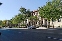
Streetscape near Côte-des-Neiges Road; Côte-des-Neiges Road (officially chemin de la Côte-des-Neiges) is a street in Montreal, home to Plaza Côte-des-Neiges and served by Métro Côte-des-Neiges. It extends from the intersection Sherbrooke Street and Guy Street in the south to the intersection of Jean-Talon Street and Laird Boulevard in the north. It is the economic and cultural heart of the Côte-des-Neiges neighbourhood. Côte-des-Neiges (English: Snows Hill) is a working class neighbourhood situated at the geographic center of the Island of Montreal on the western slope of Mount Royal. The neighbourhood is part of the borough of Côte-des-Neiges--Notre-Dame-de-Grâce. It is also known as Uptown by some of its residents. Historically, the original settlement, the Village of Côte-des-Neiges, was founded in 1862 and annexed by Montreal in two parts in 1908 and 1910. Source: Wikipedia; http://en.wikipedia.org/wiki/Main_Page (accessed 7/12/2010)
Type of Work
topographical view; photographSubject
architecture, business, commerce and trade, cityscape, City planning, Twenty-first century
Rights
Rights Statement
Licensed for educational and research use by the MIT community only