| dc.coverage.spatial | Site: Louisiana (United States) | en_US |
| dc.creator | Unknown | en_US |
| dc.date.accessioned | 2011-05-23T16:42:46Z | |
| dc.date.available | 2011-05-23T16:42:46Z | |
| dc.identifier | 160137 | en_US |
| dc.identifier.uri | http://hdl.handle.net/1721.3/64272 | en_US |
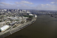
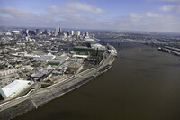
| dc.description | aerial view, view north, central business district and Crescent City Connection (also known as the 'CCC' and formerly known as the Greater New Orleans Bridge) in distance, March 1, 2011 | en_US |
| dc.relation.ispartof | 128945 | en_US |
| dc.rights | © Alex S. MacLean / Landslides | en_US |
| dc.subject | Urban planning | en_US |
| dc.subject | Cities and towns | en_US |
| dc.subject | Louisiana | en_US |
| dc.subject | Louisiana Purchase | en_US |
| dc.subject | Land use, Urban | en_US |
| dc.subject | Architecture, American | en_US |
| dc.subject | Warehouses | en_US |
| dc.subject | Aerial views | en_US |
| dc.subject | Smokestacks | en_US |
| dc.subject | High-rise buildings | en_US |
| dc.subject | Mississippi River | en_US |
| dc.subject | Central business districts | en_US |
| dc.subject | Wharves | en_US |
| dc.subject | Aerial photography --United States | en_US |
| dc.subject | Crescent City Connection | en_US |
| dc.subject | Cantilever bridges | en_US |
| dc.subject | Port of New Orleans | en_US |
| dc.title | City of New Orleans | en_US |
| dc.type | Image | en_US |
| dc.rights.access | Licensed for educational and research use by the MIT community only | en_US |
| dc.identifier.vendorcode | 110301-0341.tif | en_US |
| vra.culturalContext | American | en_US |
| vra.worktype | City | en_US |
| dc.contributor.display | American | en_US |


