| dc.coverage.spatial | Site: Louisiana (United States) | en_US |
| dc.creator | Unknown | en_US |
| dc.date.accessioned | 2011-03-18T14:53:10Z | |
| dc.date.available | 2011-03-18T14:53:10Z | |
| dc.identifier | 157532 | en_US |
| dc.identifier.uri | http://hdl.handle.net/1721.3/61962 | en_US |
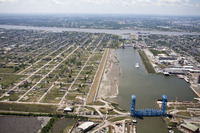
| dc.description | aerial view, Florida Avenue bridge over Industrial Canal, looking south; destroyed Lower Ninth Ward, left, April 18, 2007 | en_US |
| dc.relation.ispartof | 128945 | en_US |
| dc.rights | © Alex S. MacLean / Landslides | en_US |
| dc.subject | Urban planning | en_US |
| dc.subject | Cities and towns | en_US |
| dc.subject | Louisiana | en_US |
| dc.subject | Louisiana Purchase | en_US |
| dc.subject | Land use, Urban | en_US |
| dc.subject | Architecture, American | en_US |
| dc.subject | Bridges | en_US |
| dc.subject | Canals | en_US |
| dc.subject | Aerial views | en_US |
| dc.subject | Aerial photography --United States | en_US |
| dc.subject | Levees | en_US |
| dc.subject | Hurricane Katrina, 2005 | en_US |
| dc.title | City of New Orleans | en_US |
| dc.type | Image | en_US |
| dc.rights.access | Licensed for educational and research use by the MIT community only | en_US |
| dc.identifier.vendorcode | 070418-0008.tif | en_US |
| vra.culturalContext | American | en_US |
| vra.worktype | City | en_US |
| dc.contributor.display | American | en_US |