| dc.coverage.spatial | Site: Veneto (Italy) | en_US |
| dc.coverage.temporal | creation date: sparsely settled woodland, ca.1000-1100, alteration date: Brentella Canal, ca.1400-1500, alteration date: municipality developed, ca.1800-1870 | en_US |
| dc.creator | Unknown | en_US |
| dc.date | 1000-1100 | en_US |
| dc.date.accessioned | 2010-11-19T21:37:06Z | |
| dc.date.available | 2010-11-19T21:37:06Z | |
| dc.date.issued | 1000-1100 | en_US |
| dc.identifier | 149568 | en_US |
| dc.identifier.uri | http://hdl.handle.net/1721.3/57878 | en_US |
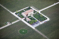
| dc.description | aerial view, villa, at intersection surrounded by vineyards, with a private helicopter pad, 10/2/2009 | en_US |
| dc.relation.ispartof | 140345 | en_US |
| dc.rights | © Alex S. MacLean / Landslides | en_US |
| dc.subject | Urban planning | en_US |
| dc.subject | Land use, Urban | en_US |
| dc.subject | City planning | en_US |
| dc.subject | Cities and towns -- Italy | en_US |
| dc.subject | Veneto (Italy) | en_US |
| dc.subject | Helicopters | en_US |
| dc.subject | Vineyards | en_US |
| dc.subject | Villas | en_US |
| dc.subject | Carports | en_US |
| dc.subject | Flat landscapes | en_US |
| dc.subject | Intersections | en_US |
| dc.title | Town of Crocetta del Montello | en_US |
| dc.title.alternative | Town of Crocetta Trevigiana | en_US |
| dc.type | Image | en_US |
| dc.rights.access | Licensed for educational and research use by the MIT community only | en_US |
| dc.identifier.vendorcode | 091002-1048 | en_US |
| vra.culturalContext | Italian | en_US |
| vra.technique | construction | en_US |
| vra.worktype | Town | en_US |
| dc.contributor.display | Italian | en_US |