| dc.coverage.spatial | Site: Veneto (Italy) | en_US |
| dc.coverage.temporal | creation date: joins the Republic of Padua, 13th century | en_US |
| dc.creator | Unknown | en_US |
| dc.date | 13th century | en_US |
| dc.date.accessioned | 2010-10-15T13:34:49Z | |
| dc.date.available | 2010-10-15T13:34:49Z | |
| dc.date.issued | 1200-1299 | en_US |
| dc.identifier | 149479 | en_US |
| dc.identifier.uri | http://hdl.handle.net/1721.3/56862 | en_US |
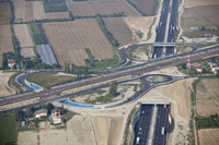
| dc.description | aerial view, intersection of railroad tracks, local roads and the A4 highway, 9/29/2009 | en_US |
| dc.relation.ispartof | 140281 | en_US |
| dc.rights | © Alex S. MacLean / Landslides | en_US |
| dc.subject | Urban planning | en_US |
| dc.subject | Land use, Urban | en_US |
| dc.subject | Cities and towns -- Italy | en_US |
| dc.subject | City planning -- Italy | en_US |
| dc.subject | Veneto (Italy) | en_US |
| dc.subject | Agricultural buildings | en_US |
| dc.subject | Agricultural land | en_US |
| dc.subject | Farmhouses | en_US |
| dc.subject | Traffic circles | en_US |
| dc.subject | Overpasses | en_US |
| dc.subject | Railroad tracks | en_US |
| dc.subject | Express highways | en_US |
| dc.subject | Aerial photography -- Italy | en_US |
| dc.title | Town of Mirano | en_US |
| dc.type | Image | en_US |
| dc.rights.access | Licensed for educational and research use by the MIT community only | en_US |
| dc.identifier.vendorcode | 090929-0434 | en_US |
| vra.culturalContext | Italian | en_US |
| vra.technique | construction | en_US |
| vra.worktype | Town | en_US |
| dc.contributor.display | Italian | en_US |