Atlases of the City of Boston, G.W. Bromley & Co., 1883 & 1902
Browse by
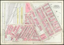
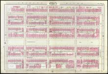
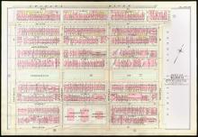
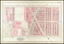
This collection contains the digitized plates of two atlases of Boston from actual surveys and official records made by the civil engineering firm G.W. Bromley & Co. for fire insurance purposes. The two atlases were published in 1883 and 1902 respectively. Neighborhoods surveyed include only Boston proper. The actual maps are 20 ½ inches by 30 inches. MIT will be digitizing a selection of Bromley atlases over the next few years.
The atlases are located in the Limited Access collection in Rotch Library:
Recent Submissions
-
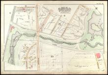
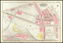
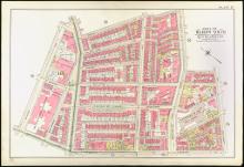
Atlas of the City of Boston, Boston Proper and Back Bay, from Actual Surveys and Official Plans (1902)
(Repository: Rotch Library, Massachusetts Institute of Technology (Cambridge, Massachusetts, United States), 1902) -
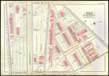
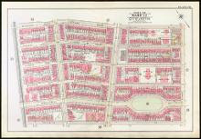
Atlas of the City of Boston, Boston Proper and Back Bay, from Actual Surveys and Official Plans (1902)
(Repository: Rotch Library, Massachusetts Institute of Technology (Cambridge, Massachusetts, United States), 1902) -
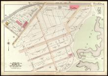
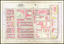
Atlas of the City of Boston, Boston Proper and Back Bay, from Actual Surveys and Official Plans (1902)
(Repository: Rotch Library, Massachusetts Institute of Technology (Cambridge, Massachusetts, United States), 1902) -
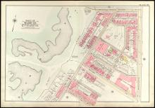
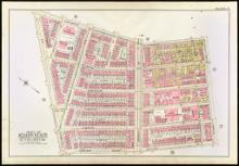
Atlas of the City of Boston, Boston Proper and Back Bay, from Actual Surveys and Official Plans (1902)
(Repository: Rotch Library, Massachusetts Institute of Technology (Cambridge, Massachusetts, United States), 1902) -
Atlas of the City of Boston, Boston Proper and Back Bay, from Actual Surveys and Official Plans (1902)
(Repository: Rotch Library, Massachusetts Institute of Technology (Cambridge, Massachusetts, United States), 1902) -
Atlas of the City of Boston, Boston Proper and Back Bay, from Actual Surveys and Official Plans (1902)
(Repository: Rotch Library, Massachusetts Institute of Technology (Cambridge, Massachusetts, United States), 1902) -
Atlas of the City of Boston, Boston Proper and Back Bay, from Actual Surveys and Official Plans (1902)
(Repository: Rotch Library, Massachusetts Institute of Technology (Cambridge, Massachusetts, United States), 1902) -
Atlas of the City of Boston, Boston Proper and Back Bay, from Actual Surveys and Official Plans (1902)
(Repository: Rotch Library, Massachusetts Institute of Technology (Cambridge, Massachusetts, United States), 1902) -
Atlas of the City of Boston, Boston Proper and Back Bay, from Actual Surveys and Official Plans (1902)
(Repository: Rotch Library, Massachusetts Institute of Technology (Cambridge, Massachusetts, United States), 1902) -
Atlas of the City of Boston, Boston Proper and Back Bay, from Actual Surveys and Official Plans (1902)
(Repository: Rotch Library, Massachusetts Institute of Technology (Cambridge, Massachusetts, United States), 1902) -
Atlas of the City of Boston, Boston Proper and Back Bay, from Actual Surveys and Official Plans (1902)
(Repository: Rotch Library, Massachusetts Institute of Technology (Cambridge, Massachusetts, United States), 1902) -
Atlas of the City of Boston, Boston Proper and Back Bay, from Actual Surveys and Official Plans (1902)
(Repository: Rotch Library, Massachusetts Institute of Technology (Cambridge, Massachusetts, United States), 1902) -
Atlas of the City of Boston, Boston Proper and Back Bay, from Actual Surveys and Official Plans (1902)
(Repository: Rotch Library, Massachusetts Institute of Technology (Cambridge, Massachusetts, United States), 1902) -
Atlas of the City of Boston, Boston Proper and Back Bay, from Actual Surveys and Official Plans (1902)
(Repository: Rotch Library, Massachusetts Institute of Technology (Cambridge, Massachusetts, United States), 1902) -
Atlas of the City of Boston, Boston Proper and Back Bay, from Actual Surveys and Official Plans (1902)
(Repository: Rotch Library, Massachusetts Institute of Technology (Cambridge, Massachusetts, United States), 1902) -
Atlas of the City of Boston, Boston Proper and Back Bay, from Actual Surveys and Official Plans (1902)
(Repository: Rotch Library, Massachusetts Institute of Technology (Cambridge, Massachusetts, United States), 1902) -
Atlas of the City of Boston, Boston Proper and Back Bay, from Actual Surveys and Official Plans (1902)
(Repository: Rotch Library, Massachusetts Institute of Technology (Cambridge, Massachusetts, United States), 1902) -
Atlas of the City of Boston, Boston Proper and Back Bay, from Actual Surveys and Official Plans (1902)
(Repository: Rotch Library, Massachusetts Institute of Technology (Cambridge, Massachusetts, United States), 1902) -
Atlas of the City of Boston, Boston Proper and Back Bay, from Actual Surveys and Official Plans (1902)
(Repository: Rotch Library, Massachusetts Institute of Technology (Cambridge, Massachusetts, United States), 1902) -
Atlas of the City of Boston, Boston Proper and Back Bay, from Actual Surveys and Official Plans (1902)
(Repository: Rotch Library, Massachusetts Institute of Technology (Cambridge, Massachusetts, United States), 1902)