| dc.coverage.spatial | Site: Bapchule (Arizona, United States) | en_US |
| dc.creator | Unknown | en_US |
| dc.date | Unavailable | en_US |
| dc.date.accessioned | 2009-10-23T19:56:58Z | |
| dc.date.available | 2009-10-23T19:56:58Z | |
| dc.date.issued | Unavailable | en_US |
| dc.identifier | 130424 | en_US |
| dc.identifier.uri | http://hdl.handle.net/1721.3/44653 | en_US |
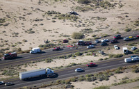
| dc.description | aerial view, traffic back-up on I-10 due to automobile accident | en_US |
| dc.relation.ispartof | 138269 | en_US |
| dc.rights | © Alex S. MacLean / Landslides | en_US |
| dc.subject | Deserts | en_US |
| dc.subject | Southwest (U.S.) | en_US |
| dc.subject | Arizona | en_US |
| dc.subject | Cities and towns -- United States | en_US |
| dc.subject | Unincorporated areas | en_US |
| dc.subject | Indian reservations | en_US |
| dc.subject | Gila River Indian Community, Gila River Reservation, Arizona | en_US |
| dc.subject | Automobiles | en_US |
| dc.subject | Highways | en_US |
| dc.subject | Traffic accidents | en_US |
| dc.subject | Traffic congestion | en_US |
| dc.subject | Aerial photography --United States | en_US |
| dc.title | Town of Bapchule | en_US |
| dc.type | Image | en_US |
| dc.rights.access | Licensed for educational and research use by the MIT community only | en_US |
| dc.identifier.vendorcode | 041216-0111.tif | en_US |
| vra.culturalContext | American | en_US |
| vra.worktype | Town | en_US |
| dc.contributor.display | American | en_US |