| dc.coverage.spatial | Site: Buckeye (Arizona, United States) | en_US |
| dc.coverage.temporal | creation date: incorporated, 1926 | en_US |
| dc.creator | Unknown | en_US |
| dc.date | 1926 | en_US |
| dc.date.accessioned | 2009-10-23T19:43:11Z | |
| dc.date.available | 2009-10-23T19:43:11Z | |
| dc.date.issued | 1926 | en_US |
| dc.identifier | 130375 | en_US |
| dc.identifier.uri | http://hdl.handle.net/1721.3/44503 | en_US |
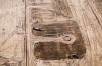
| dc.description | aerial view, street grading work for subdivision | en_US |
| dc.relation.ispartof | 138271 | en_US |
| dc.rights | © Alex S. MacLean / Landslides | en_US |
| dc.subject | Deserts | en_US |
| dc.subject | Urban planning | en_US |
| dc.subject | Southwest (U.S.) | en_US |
| dc.subject | Arizona | en_US |
| dc.subject | Townscapes (built environment) | en_US |
| dc.subject | Land use, Urban | en_US |
| dc.subject | Cities and towns -- United States | en_US |
| dc.subject | Housing developments | en_US |
| dc.subject | Construction | en_US |
| dc.subject | Aerial photography --United States | en_US |
| dc.subject | Grading | en_US |
| dc.title | Town of Buckeye | en_US |
| dc.type | Image | en_US |
| dc.rights.access | Licensed for educational and research use by the MIT community only | en_US |
| dc.identifier.vendorcode | 041215-0295.tif | en_US |
| vra.culturalContext | American | en_US |
| vra.worktype | Town | en_US |
| dc.contributor.display | American | en_US |