
Secunderābād and Bolārum Guide Map
Download125747_cp.jpg (1.751Mb)
Alternative Title
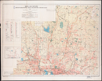
Secunderabad and Bolarum Guide Map
Description
Relief shown by contours, hachures, form lines, and spot heights. Includes index to points of interest and "Index to tāluks, cantonment, municipal corporations and municipal wards, scale 1:125,000."
Map of bus routes on verso. full view
Type of Work
MapSubject
Cartography, Land use, Urban, Secunderābād (India), India -- Maps
Rights
Rights Statement
All rights reserved
Item is Part of
136207