
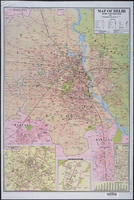
Map of Delhi, Political cum Road Map
Download125753_cp.jpg (1.479Mb)
Description
Shows the Union Territory of Delhi and includes portions of Haryana and Uttar Pradesh. Selected buildings shown pictorially. Includes insets of Connaught place, Chanakyapuri, and "Excursions around Delhi", and graph showing monthly temperature and precipitation. full view
Type of Work
MapSubject
Cartography, Delhi (India), Land use, Urban, Cities and towns -- India, India -- Maps, Maps, Tourist, Roads -- Maps
Rights
Rights Statement
All rights reserved
Item is Part of
136233