| dc.creator | Munn, Leonard (English, 1878-1935), surveyor | en_US |
| dc.date.accessioned | 2008-07-02T05:15:54Z | |
| dc.date.available | 2008-07-02T05:15:54Z | |
| dc.date.created | October 1913 (creation) | en_US |
| dc.date.created | 1915 (publication) | en_US |
| dc.date.issued | 2008-07-02T05:15:54Z | |
| dc.identifier | 113091 | en_US |
| dc.identifier.other | 131806 | en_US |
| dc.identifier.uri | http://hdl.handle.net/1721.3/27531 | |
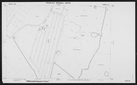
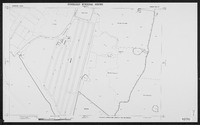
| dc.description | map, Maghak and Jiagura Road visible | en_US |
| dc.format.medium | paper (fiber product) | en_US |
| dc.format.medium | ink | en_US |
| dc.subject | Cartography | en_US |
| dc.subject | Maps | en_US |
| dc.subject | Urban planning | en_US |
| dc.subject | Islamic cities and towns | en_US |
| dc.subject | Architecture, Islamic --India | en_US |
| dc.subject | Surveys | en_US |
| dc.subject | Historical geography --Maps | en_US |
| dc.subject | Hyderabad (India) | en_US |
| dc.title | Sheet no. 27, Karwan Area | en_US |
| dc.title.alternative | Sheet no. 27, Karwan Area | en_US |


