| dc.coverage.spatial | Site: Île-de-France (France) | en_US |
| dc.coverage.temporal | creation date: original settlement, 3rd century BCE, other date: renamed Paris, early 4th century CE | en_US |
| dc.creator | Unknown | en_US |
| dc.date | 3rd century BCE | en_US |
| dc.date.accessioned | 2014-09-25T15:50:57Z | |
| dc.date.available | 2014-09-25T15:50:57Z | |
| dc.date.issued | -299--200 | en_US |
| dc.identifier | 249633 | en_US |
| dc.identifier.uri | http://hdl.handle.net/1721.3/164057 | |
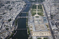
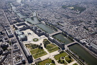
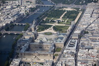
| dc.description | aerial view, looking down the Left and Right Banks of the Seine with Île Saint-Louis and Île de la Cité, Notre Dame and numerous bridges linked to the city with the Eiffel Tower and La Defense in the background, 5/28/2010 | en_US |
| dc.relation.ispartof | 138144 | en_US |
| dc.rights | © Alex S. MacLean / Landslides | en_US |
| dc.subject | Urban planning | en_US |
| dc.subject | Land use, Urban | en_US |
| dc.subject | Cities and towns -- France | en_US |
| dc.subject | City planning -- France | en_US |
| dc.subject | Bridges | en_US |
| dc.subject | Aerial views | en_US |
| dc.subject | Islands | en_US |
| dc.subject | Seine River (France) | en_US |
| dc.subject | Ile de la Cité (Paris, France) | en_US |
| dc.subject | Aerial photography -- France | en_US |
| dc.subject | Saint-Louis, Île (Île-de-France, France) | en_US |
| dc.title | City of Paris | en_US |
| dc.type | Image | en_US |
| dc.rights.access | Licensed for educational and research use by the MIT community only | en_US |
| dc.identifier.vendorcode | 100528-0104 | en_US |
| vra.culturalContext | French | en_US |
| vra.technique | construction | en_US |
| vra.worktype | City | en_US |
| dc.contributor.display | French | en_US |