South Boston

Download247819_cp.jpg (579.5Kb)
Date
1804Description
aerial view, South Boston side of the Fort Point Channel with parellel pedestrian pathway, 6/3/2011
Type of Work
NeighborhoodSubject
Urban planning, Urban renewal, Neighborhoods, Land use, Urban, City planning, South Boston (Boston, Mass.), Aerial views, Channels (water body components), Fort Point Channel Area (Boston, Mass.), South Boston Waterfront (Boston, Mass.), Aerial photography --United States
Rights
Rights Statement
Licensed for educational and research use by the MIT community only
Item is Part of
143954
Metadata
Show full item recordCollections
Related items
Showing items related by title, author, creator and subject.
-
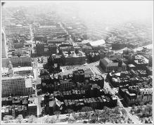
Aerial View Looking South, Copley Square, South End
(Repository: Rotch Visual Collections, Massachusetts Institute of Technology (Cambridge, Massachusetts, United States) ID: Kepes/Lynch Collection, 40.28, 1957) -
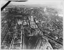
Aerial View from Plane, Looking East, Boylston Street to Intersection with Huntington Avenue, Large Rail Yard, John Hancock Building, Boston Skyline and Harbor in Background
(Repository: Rotch Visual Collections, Massachusetts Institute of Technology (Cambridge, Massachusetts, United States) ID: Kepes/Lynch Collection, 40.06, 1957) -
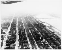
Aerial View, Back Bay, Copley Square, Looking Southwest, Commonwealth Avenue, Charles River
(Repository: Rotch Visual Collections, Massachusetts Institute of Technology (Cambridge, Massachusetts, United States) ID: Kepes/Lynch Collection, 40.09, 1957)