| dc.creator | unknown (English) | en_US |
| dc.date | 1661 | |
| dc.date.accessioned | 2007-01-30T21:48:32Z | |
| dc.date.available | 2007-01-30T21:48:32Z | |
| dc.date.issued | 1661 | |
| dc.identifier | 101344 | en_US |
| dc.identifier.uri | http://hdl.handle.net/1721.3/15644 | en_US |
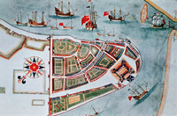
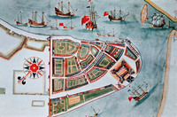
| dc.description | detail, lower Manhattan | en_US |
| dc.format.medium | paper (fiber product) | en_US |
| dc.format.medium | ink | en_US |
| dc.relation.ispartof | 129203 | en_US |
| dc.subject | Cartography | en_US |
| dc.subject | Imperialism | en_US |
| dc.subject | Maps | en_US |
| dc.subject | New York (N.Y.) | en_US |
| dc.subject | United States --History --Colonial period, ca. 1600-1775 | en_US |
| dc.subject | United States -- Maps | en_US |
| dc.subject | Colonies | en_US |
| dc.subject | Historical geography --Maps | en_US |
| dc.subject | Cities and towns --Growth | en_US |
| dc.title | Duke's plan of New York | en_US |
| dc.title.alternative | Duke's Map of New York as New Amsterdam | en_US |
| dc.title.alternative | A description of the towne of Mannados or New Amsterdam as it was in September 1661 | en_US |
| dc.type | Image | en_US |
| dc.rights.access | All rights reserved | en_US |
| dc.publisher.institution | Repository: British Library (London, England) | en_US |
| vra.culturalContext | English | en_US |
| vra.culturalContext | Dutch | en_US |
| vra.culturalContext | American | en_US |
| vra.technique | cartography | en_US |
| vra.worktype | Engraving (print) | en_US |
| vra.worktype | Historical map | en_US |
| dc.contributor.display | unknown (English) | en_US |


