
Beaufort: Topographic Views of Historic District
Download1B3-AB-B-K2_cp.jpg (724.1Kb)
Date
1997Description
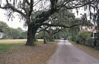
View along Hancock Street showing live oak canopy; The community which is now Beaufort had its beginning in 1710, when Barbadian planters, English indenture servants, tradesmen, and religious dissenters came here to seek their fortunes. These early settlers built houses of clapboard and of tabby, a durable cement-like material composed of oyster shells, sand and a lime obtained through the burning of oyster shells. As prosperity increased, the houses grew larger and more elaborate. Designed for airiness and coolness, the "Beaufort Style" incorporated elements of Georgian and Colonial architecture as well as those of Greek Revival and semi-tropical Spanish. House building in Beaufort reached its peak during the years 1820-1860. During and after the Civil War, the houses were sold at auction by the Federal Government. Only a very few of the original owners were able to reclaim their homes. Several were bought by former slaves, some by former Union soldiers, and several by Northerners who came to Beaufort as participants in the Reconstruction effort. There is a National Historic Landmark District. The Point neighborhood (also known as the Old Point) is home to some of Beaufort's largest, oldest, and most expensive homes. Defined as the land between Carteret Street and the Beaufort River. Source: Beaufort Online [website]; http://www.beaufortonline.com/ (accessed 5/3/2011)
Type of Work
topographical view; photographSubject
architecture, cityscape, Restoration and conservation, Twentieth century
Rights
Rights Statement
Licensed for educational and research use by the MIT community only