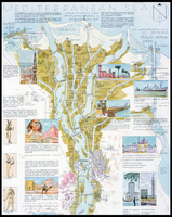
Map of Egypt Showing Ancient Sites along the Nile River
| dc.coverage.spatial | Site: Egypt (Egypt) | en_US |
| dc.coverage.temporal | other date: dates depicted in map, ca. 4000-ca. 30 BCE | en_US |
| dc.creator | unknown (undetermined) | en_US |
| dc.date | ca. 4000-ca. 30 BCE | en_US |
| dc.date.accessioned | 2006-10-17T13:53:48Z | |
| dc.date.available | 2006-10-17T13:53:48Z | |
| dc.date.issued | -4000 | en_US |
| dc.identifier | 046741 | en_US |
| dc.identifier.uri | http://hdl.handle.net/1721.3/11807 | en_US |
| dc.description | full view | en_US |
| dc.format.medium | paper (fiber product) | en_US |
| dc.format.medium | ink | en_US |
| dc.relation.ispartof | 127516 | en_US |
| dc.subject | Cartography | en_US |
| dc.subject | Egypt --Antiquities | en_US |
| dc.subject | Egypt -- Description and travel | en_US |
| dc.subject | Egypt --History | en_US |
| dc.subject | Nile River | en_US |
| dc.subject | Architecture, Ancient --Egypt | en_US |
| dc.subject | Egypt --Maps | en_US |
| dc.title | Map of Egypt Showing Ancient Sites along the Nile River | en_US |
| dc.type | Image | en_US |
| dc.rights.access | All rights reserved | en_US |
| vra.culturalContext | Egyptian (ancient) | en_US |
| vra.technique | cartography | en_US |
| vra.worktype | Map | en_US |
| dc.contributor.display | unknown (undetermined) | en_US |
Files in this item


This item appears in the following Collection(s)
-
Architecture, Urban Planning, and Visual Arts
Online Image Collection
Related items
Showing items related by title, author, creator and subject.
-
Darb al-Ahmar
(909-1171) -
Darb al-Ahmar
(909-1171)